Sherri and I accomplished a descent amount of driving miles the first day as we headed toward California on our 2019 National Parks trip. Normally, Wal-mart has been a welcome site when looking for a place to park & rest for the night, with 24-hour access to snacks and restrooms. However, upon strolling into the Wal-mart in Soix, IO after a long day of driving, some guy rushed us at the door asking if he could catch a ride to “the carnival.” Shaking our heads in confusion, we quickly shuffled into the store and did our shopping. On our way out of the store, Carnival Guy approaches us again asking the same question. This confirmed our suspicions that he wasn’t quite firing on all cylinders. Locking the car doors, and cracking the windows only wide enough to keep us from suffocating, we attempted to sleep with one eye open in case other strangers came around. Not even an hour later, I woke up to a talon grip digging into my arm as Sherri frantically pointed out the window. Carnival Guy had begun wandering our way, cussing up a storm, and swinging his grocery bag as if swatting mosquitoes. Groggily, I started the car while attempting to roll up the windows by pressing all of the buttons at the same time. We high-tailed it out of there following google navigation on a string of backroads that led us to the opposite side of the fence from a rest stop. After swiping google maps away in frustration, we drove a couple more miles until finally getting onto the highway, and then pulled off at the rest stop exit. We slept with relative peace of mind, but I’m afraid that Crazy Carnival Guy will always remain in the back of our minds whenever driving through Iowa.


Early the next morning, we pulled into the shuttle service for Channel Islands National Park where we boarded The Explorer, and set out to sea towards Santa Cruz Island. About an hour into our trip, we caught glimpses of dolphins playing in the wake of our ship. After passing a couple of deep water oil rigs, the misty island slowly came into view. Immediately after setting foot on the island, a park ranger huddled everyone together for a safety talk. As the ranger started wrapping up his scripted speech, Sherri and I began sneaking away from the crowd in an attempt to get a headstart on some of the other hikers. Winding our way up the beach cliffs toward Smuggler’s Bay, we only noticed a few hikers following us- The Newlyweds, and Hiker Joe. The Newlyweds posed no threat since they were far more interested in gleefully snapping selfies of each other. Hiker Joe, on the other hand, was making serious headway. From a distance, it appeared as though his legs hinged from his armpits, gliding with flamingo-like strides. His black, rice paddy hat steadily keeping pace with us. At one point, I searched through my binoculars to assess the gap between Hiker Joe and us. My competitive imagination caught a glimpse of him looking right back at us through his own binoculars, prompting us to quicken our pace toward Smuggler’s Bay. Upon reaching the highly anticipated beach, we noticed a sea lion pop his head above the surf, then dive again. Most of the island was arid desert, supporting only prickly, low-lying bushes and shrubs, except in these rare pockets of moisture rich land areas harboring massive beach trees and tropical looking ferns. The temperature also dropped a good 5-10 degrees, providing some reprieve from the unrelenting force of the sun on our necks. Making our way across to the other side of the island, we traversed along the steep cliffs of the northern shoreline. Pelicans gliding on thermals rose up from the shoreline directly in front of us. We must have parked there for a good half hour capturing photos and video of the aerial exhibition. Sherri and I high-fived our decision not to camp on the island that night, content with our day visit as the heat and lackluster scenery hurried us along to board the ferry returning us to the mainland. On our way out of town, we stopped at a local brewery for a cold one and 2 for 1 tamales. We shared stories with an old-timer who pulled up a stool next to us, attempting to convince us that IPAs are the best tasting beer. That night, we almost made it to Pinnacles National Park, but played it safe by pulling into a rest area to catch a few winks.


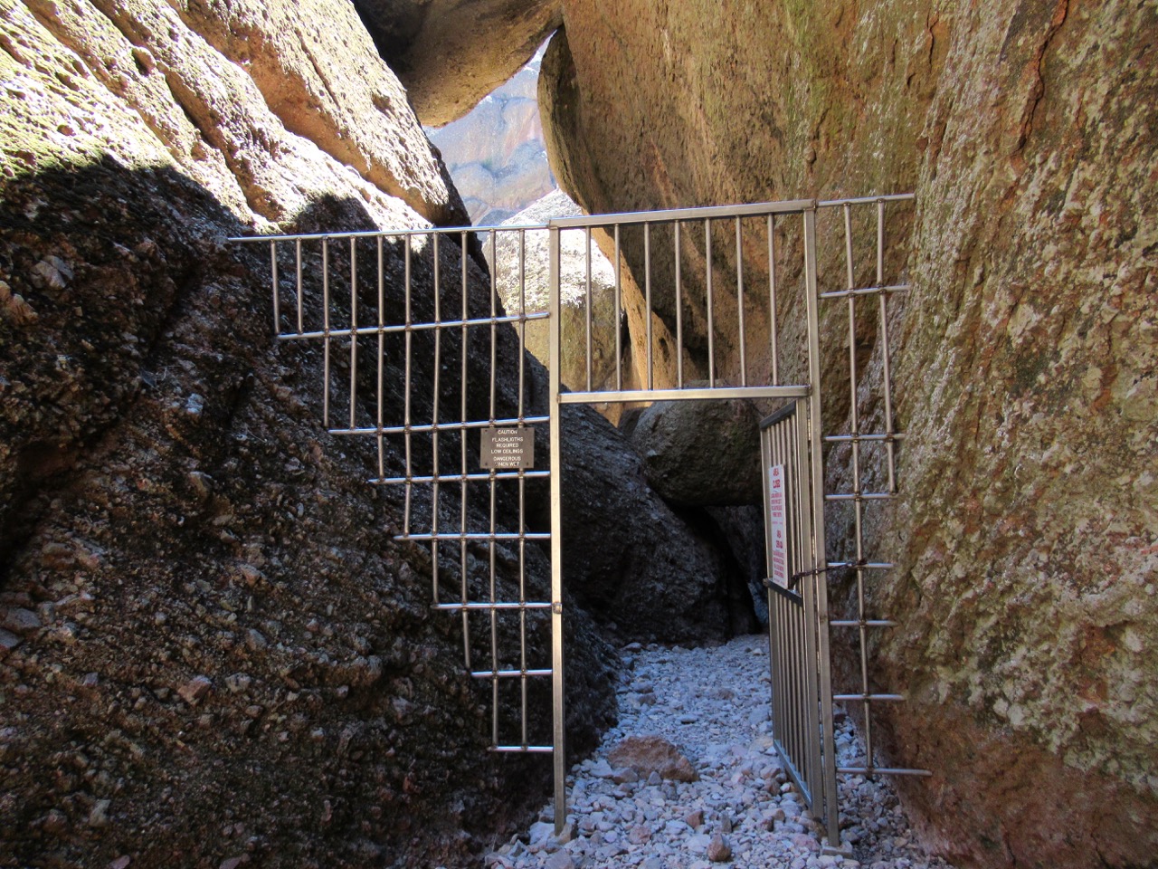
Driving into Pinnacles the next morning, we noticed something rarely found at National Parks- a swimming pool! Thanks to the YMCA Nationwide program, we had already been traveling in luxury with access to showers and pools throughout most of our travels thus far. After setting up camp, we set out on a trail leading up to “The Ledges.” The path then led us back down into a cave network, which is actually a labyrinth of drainage tunnels underneath a conglomeration of massive boulders. At one point, the passageway became so narrow, that I had to ditch my pack in order to fit through the tightening caverns. Afterwards, we continued up to Condor Canyon, which definitely lived up to its name. Climbing higher and higher toward the ridgeline, we observed at eye level, massive Condors soaring like ancient Pterodactyls. We learned that these birds can grow to have a 9 foot wingspan- incredible! Rarely flapping their wings, these pirates of the sky surveyed the distant valley below for carcasses. While passing over the ridge around huge rock spires, we came upon a group of condors perched in a Ponderosa Pine, taking a break from the midday sun to preen their feathers. Occasionally, one would drop from the tree into an instant glide, soaring directly overhead to the other side of the canyon wall, displaying its enormous V-shaped wing pattern. Logging over 12 miles of intense hiking that afternoon, we limped over to the swimming pool where we attempted some underwater stretching exercises, accompanied by plenty of grimacing and laughing. Completely exhausted, we hit the hay earlier than the screaming kids at the campsite next to us. Eventually, the sounds of night nature took over as we studied the stars through the roof of our tent.


Hiking up to Moses Lake the next morning provided another vantage point from which to study the impressive rock formations that earned this park its name. Shortly after leaving the park, California traffic smacked us around pretty good as we attempted to re-route around a sling of accidents. It’s no surprise since the average driver down there floors it at least 40 mph above the speed limit- no joke. At one point, we simply decided to pull off the jam-packed highway, and visit a local brewery- sometimes sacrifices have to be made. Continuing our laborious drive out of CA, we stretched our legs on an evening hike that Sherri scouted online for us near Mt. Shasta. Unfortunately, daylight had been sucked pretty well dry by this time, pushing us up against the clock. Chasing the sunset into the foothills, we strapped on our headlamps knowing full well that nighttime would accompany us on our return trip. Fortunately, Sherri had just enough phone battery to keep us on track toward the viewpoint since a ton of other minor foot paths criss-crossed the main trail, often leading us astray toward random overlooks. Eventually, we came upon a placid lake with mossy rocks bordering its shoreline, black as oil against the dimly lit canyon. Turning around, we discovered the mighty Mt. Shasta looming in the distance, colored deep purple with splashes of ripe peach stretched across the horizon. Sensing the imminent night sky rush upon us, we scampered back down the mountainside like fireflies trickling through the forest.


We spent a hilariously fun next couple of weeks visiting with friends and family in Portland, and then turned our compass toward Mt. Rainier.


 |
| Man, do I miss flying kite on the beach. |


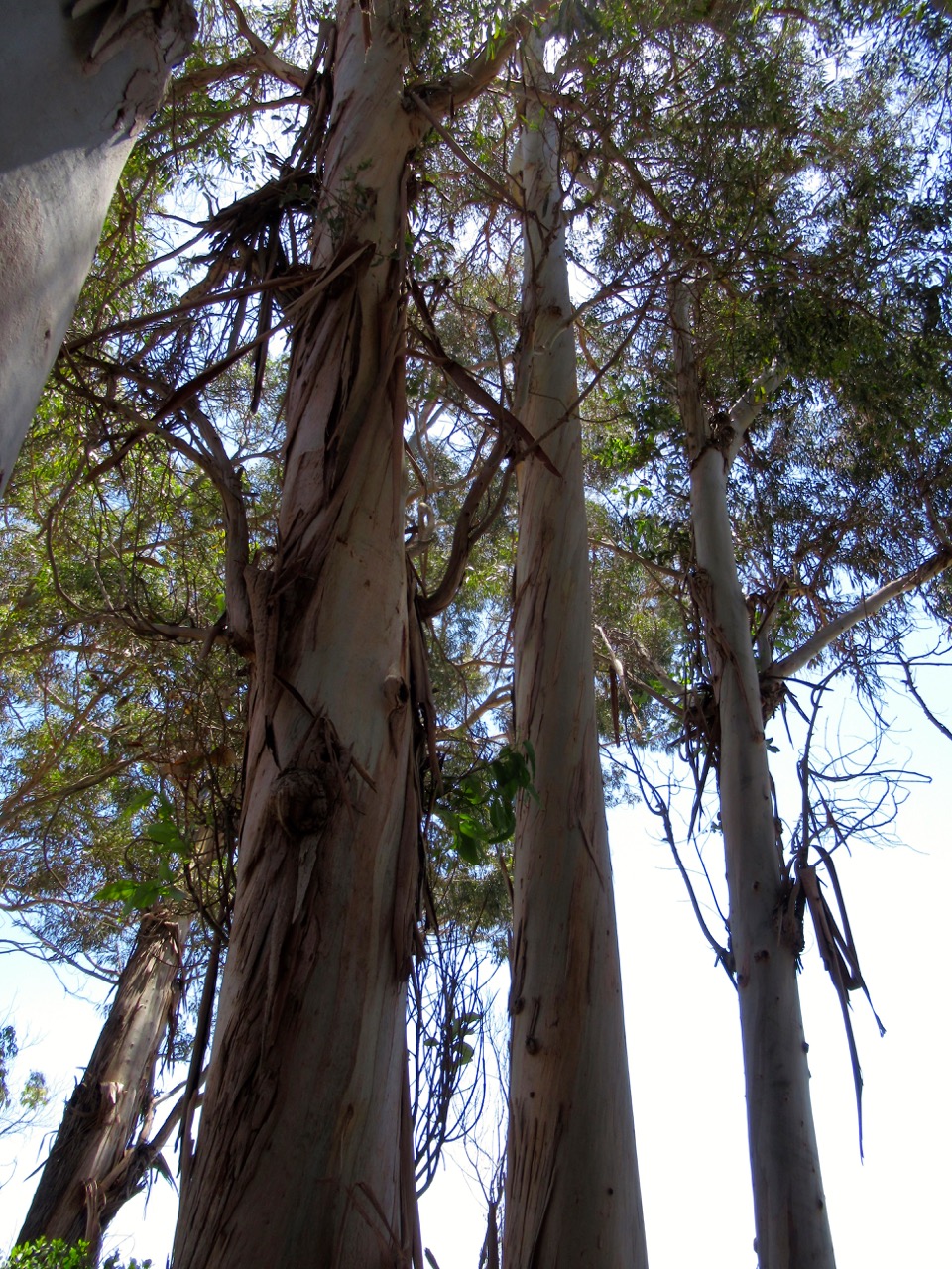
Upon entering Mt. Rainier park, we wet our nature pallets with a short hike highlighting the enormous Cedar and Fir trees far older and wiser than the park itself. Observing the sheer mass of these giants helped me gain perspective of their strength and governance over the land. Next, we drove up to Paradise Lodge where we hiked the Upper Skyline Trail. Finding a parking spot wasn’t easy since a mile long string of cars lined the one way road past the lodge parking lot. Adding another link to the automobile snake, we noticed a trail leading up into the forest along a waterfall. Upon studying the map, it proved to be an ideal little offchute trail routing us directly back to our car from the Skyline Trail. At the trailhead, a quote from John Muir engraved on granite steps inspired us to revere the author of this magnificent landscape. The path wound high up along a craggy ridge staring right into the heart of the glaciers hanging off of Rainier’s southern face. Afterwards, we drove to the wilderness center where we inquired about backpacking permits. It just so happened that a group site at Indian Bar had recently become available. Shocked, the ranger explained that this highly sought after backpacking destination has a shelter. An even bigger surprise was that there was no registration fee for backpacking- yay Mt. Rainier! Having already logged in 5 miles of rigorous climbing, we now faced another strenuous 8 miles of backpacking at 5pm in the afternoon. Mosquitos peppered us the entire first half of our climb to Indian Bar. Only until reaching the treeline a few hours later did we find some reprieve from the blood sucking onslaught. However, paying homage to the native mosquito colony was well worth the reward of catching magnificent sunset views of Mt. Rainier’s eastern face. Afraid that we might run out of daylight before reaching camp, we hustled down a steep descent to what we suspected was our destination. Below us, we noticed a river slaloming its way through a massive outcropping of rock at the base of the mountain. Eventually, a tiny stone shelter came into view, perched on a hillside overlooking the river. The cabin was a welcome site as we sprawled out our gear, and cooked a of stovetop candlelight dinner of dehydrated Lasagna, washed down with some chai tea- yum! Setting out to fetch some water that night, I looked back up at our little wilderness abode, light flickering inside from Sherri’s headlamp, the shadow of an enormous canyon wall surrounding us. It was truly one of those “doesn’t get any better than this” moments.


Sprawling out the topo map the next morning, we locked-in our first hike just up the road from the campground. The 4-wheel drive access road leading up to the Thornton Lakes trailhead was a treacherous one lane, double track path with a sheer drop-off on one side, and a cliff wall on the other. It felt like an eternity driving up higher and higher out of the valley, until finally reaching a tiny cul de sac with a handful of other cars parked cockeyed next to an outhouse. After pulling the parking break with my fingers crossed, we set-out into the forest with a slight chill in the air from the high altitude winds. Eventually, the trail led us out onto an outcropping of boulders overlooking a massive alpine lake surrounded by steep, snowy cliffs, and jagged peaks. While picnicking there, we decided not to hike down to the lake since the trail was really washed-out. Instead, we opted to climb a primitive off-chute trail leading up to Trappers Peak. We doubted our decision several times as the trail turned into a series of literal 5.9 climbing routes. Looking up ahead of us, we could see hikers clamoring around on the cliffs like Billygoats. I got the feeling that the downclimb would actually be more difficult than reaching the summit. All the while, the scenery was absolutely breathtaking as layers upon layers of mountains came into view the higher we climbed. We didn’t linger very long on the peak after noticing storm clouds forming in the west. By the time we reached the car, the sky had grown dark with winds violently rustling through the trees. Since the forecast threatened overcast skies for tonight and tomorrow, we decided to camp another night at Newhalem, and wait until skies cleared before attempting to summit the Sahale Arm.


Sure enough, all of the mountain peaks were socked-in with clouds the next morning. This made for a relaxing day in the valley, sending us on the quest for more touristy trails along the park road. In town, we walked the Trail of the Cedars where we learned about the history of forest fires in the area. Then, we explored around the Newhalem powerhouse and decrepit garden paths that once attracted visitors on their way to view Ladder Falls. Later, we drove up to Diablo overlook, and climbed Thunder Knob trail that gave us some up close views of Colonial peak, mystically fading in and out of view amidst the clouds. Since the forecast for tomorrow was shaping up nicely for a summit climb, we spent the rest of the afternoon driving up to the Sahale glacier trailhead. We knew it was going to take us awhile since the map showed nearly 30 miles of...once again, a single lane, double track road requiring us to occasionally jam it in reverse, and nervously back down the sketchy road to the last pull-out in order to avoid approaching downhill traffic- not fun. Arriving at the trailhead, we noticed people continually buzzing around, either setting-up backpacking gear, or tearing down after returning from a hike. After taking in the view of Cascade Peak while fixing dinner at a picnic table, we turned it in early that evening. Our plan was to sleep in the car for a few hours, and then hit the trail around 2am in order to catch the sunrise from the summit.


Waking up in total darkness, we strapped on our headlamps and and counted 35 switchbacks climbing up to the first ridge, accurately foretold by a hiker we met the day before. Once our night vision kicked in, we noticed a snowy mountainside slowly come into view on the other side of the valley, illuminated by a half moon positioned on the opposite side of the ridge from where we were climbing. The Milkyway stretched above and beyond like a plume of glittery smoke. From there, we continued another 2 miles past Doubtful Lake up the Sahale Arm, surpassing 7,000 ft. elevation. At this point of our climb, we were now eye level with Peyton peak and Trapper Mountain. Even more breathtaking were the views of distant peaks appearing in the distance the higher we climbed, spanning in all directions. On the way back down, I noticed an interesting looking trail on the other side of the valley that traversed across an insanely steep snowfield, and then hooked around the side of a mountain. The path looked far too extreme to appease National Park standards, and when I couldn’t find it on the topo map, I quickly realized that it was simply a goat trail. I secretly wanted to take a gander up their myself, but conceded to stay on the “designated trails.” This really was the perfect capstone experience to wrap-up our park visit.


